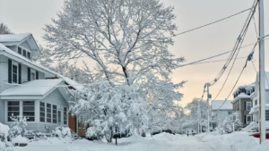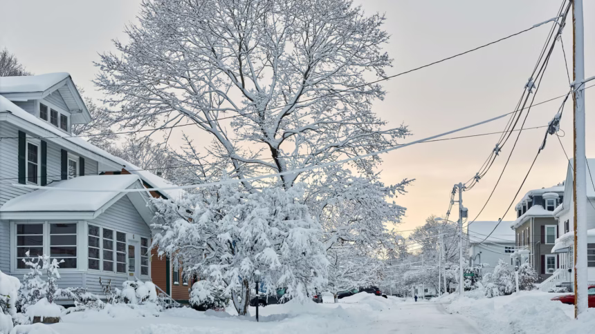
After a rainy weekend along the coast, Arctic air brings Boston its first taste of winter.
According to forecasters, a few isolated flurries—with no significant accumulation—are expected to occur on Tuesday, November 11. Meanwhile, Sunday, November 16, appears to be rainier than snowy along the coastline. Higher elevations and inland areas will be best positioned to see actual snow showers, according to the National Weather Service.
In its Tuesday technical discussion, the National Weather Service (NWS) Boston/Norton office summarized the week as follows: “cold and blustery” weather with “at best a few brief rain/snow showers,” then “a front could bring mainly rain Sunday.” This forecast supports a scenario in which Boston gets more wet than white by week’s end.
The clearest signals point to Tuesday, with unstable air and favorable flow patterns, as traveling flurries may sweep across Massachusetts courtesy of lake-effect bands originating from Ontario.
NBC10 Boston notes a “low probability of random flurries Tuesday,” matching the cold and wind, but no organized snow is expected to start the week in downtown areas.
Further north and across higher terrain (the Berkshires, White Mountains, Vermont, and Maine highlands), conditions remain cold enough for some snow showers Wednesday-Thursday as a weak disturbance passes through. “Snow showers in spots” are indeed among the NWS scenarios through Thursday, before drier and still chilly weather is expected on Friday and Saturday.
On Sunday, November 16, forecasts favor rain in Boston, with temperatures above freezing. Inland hills may see a brief rain-snow mix, but no city accumulation is expected.
The change is sudden: after mild October weather, highs will only reach 39–43°F from Tuesday to Thursday, and brisk winds will make it feel even colder.
The National Weather Service predicts that this period will bring much colder-than-usual temperatures and steady winds, along with a chance of light snow on Tuesday in parts of western Massachusetts.
In Boston itself, the episode resembles more of a winter prologue than a true first measurable snowfall, the National Weather Service explains, according to NBC10.
Expected Impacts: Roads, Coast, and Travel
Road network: wet and occasionally slippery roads possible early morning on high plateaus (bridges/overpasses), especially on Wednesday and Thursday. Downtown, vigilance will focus primarily on cold showers and gusts.
Coast: King tides caused minor overflow this weekend. Residual swells and winds mean light surf and spray at high tide, with no major coastal event expected. (NWS analysis, local trends)
Transportation: Main disruptions are expected north of the region on Wednesday and Thursday, with local snow patches at elevation. Wind and then Sunday rain are the primary concerns around Boston/Logan.
NBC10 Boston meteorologists emphasize a cold snap followed by “mostly cloudy skies for 48 hours,” with a sunnier trend over 10 days. For the Massachusetts capital, they mention “a risk of scattered flurries Tuesday,” but no prospect of significant immediate snowfall at sea level. These elements align with the NWS line: cold, active week, but snow mainly confined to inland areas.
Key Takeaways
Tuesday, November 11: scattered flurries possible in Boston, no accumulation. Biting cold and gusts expected.
Wednesday-Thursday: Light snow showers, mainly at elevation and inland; coastal areas are cold and dry/variable conditions.
Sunday, November 16: rain likely in Boston, with limited risk of snow mix on higher ground; no accumulation expected in the city according to current projections.
Advice: Dress for wind (layered windbreakers, gloves), watch for slick mornings outside the coast, and check high tide times in low-lying areas. Motorists heading to the Berkshires or New Hampshire: allow extra time on Wednesday and Thursday, and check NWS bulletins before traveling.
Boston’s first snow isn’t expected yet. Look for preview flurries, then expect rain on Sunday.
The real white season will likely await a second or third cold snap—stay tuned in the coming days for updates from NWS Boston/Norton and local weather media.